Topics 2020.07.02
Weather simulations with ultra fine resolution
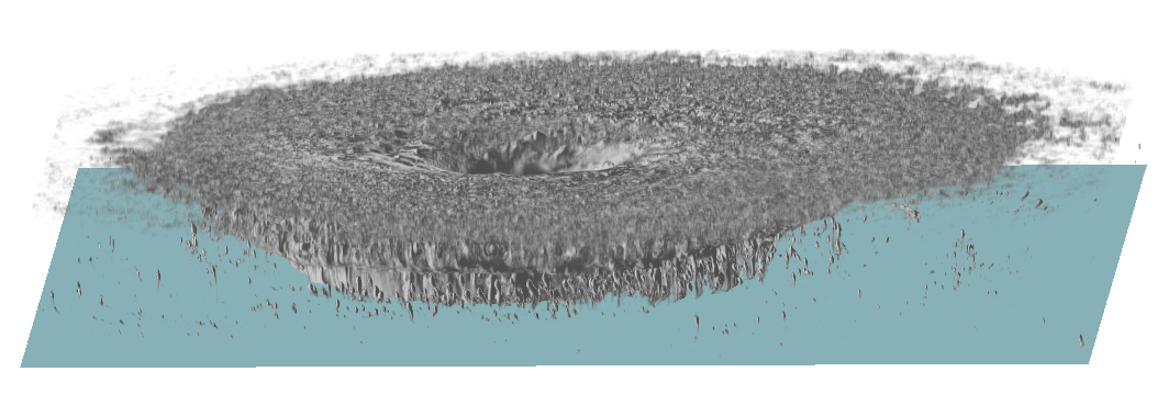
Figure 1 Simulated cloud in the simulation of an entire tropical cyclone.
The performance of supercomputers is improving year by year. In the ranking of the performance of supercomputers around the world, TOP500, the records are often rewritten by flagship supercomputers in each country. In the ranking for the first half of 2020, "Fugaku" of RIKEN became the top of the world. Modern supercomputers consist of many independent computers which communicate each other to enabling large scale parallel computations. We realize weather simulations with ultra fine resolution on a supercomputer and are conduct researches based on the results.
If the resolution becomes finer, one can expect more accurate computation, but the amount of calculation will increase rapidly (calculation amount is increased by the 4th power of resolution). If one takes longer calculation time than the time elapsed inside the simulation, simulations for predicting the future such as weather forecasts are meaningless. Simulations for research does not have such a strict restriction on the calculation time, so ultra fine resolution calculation that requires a huge amount of calculation can be realized by using a high-performance supercomputer. Amount of output data exceeds 100 TB in a single calculation. The calculation and analysis will stop if there is insufficient free disk space. Data selection strategies are also important.
We demonstrate an example of such calculation results. We set the horizontal resolution to 100 m and performed simulation with a ultra fine resolution with covering an entire tropical cyclone (Fig. 1) using the "K computer" computer, which the predecessor of Fugaku. It took half a year to simulate the developed typhoon only for 10 hours. There are few examples of weather simulations in such a huge computation size.
We especially focused on flows in the lower atmosphere. There have been no detailed observations in the vicinity of the radius where the wind speed is the maximum. This area was completely unknown, thus I was excited when the simulation results were first displayed. The result was revealed that there are 3 types of organized structures, referred as roll structures, depending on the radius (Fig. 2). Extremely strong surface wind speeds are associated with such roll structures.
There are many other points to investigate further details in the simulation. In addition to tropical cyclone, we are also conducting simulations of extreme weathers such as torrential rainfalls and tornadoes.
The supercomputer in Tohoku University will be replaced in this summer. Each replacement of a supercomputer improves the computation capacity more or less. However, even if the computation capacity is increased by x times, the resolution can be improved only by 4th root of x as a simple estimate. It may not be quite exciting by merely increasing the resolution. I am seeking a good way to take advantage of the improvements of supercomputers.
Reference: Ito, J., Oizumi, T. & Niino, H. Near-surface coherent structrures explored by large eddy simulation of entire tropical cyclones, Sci Rep, 7, 3798 (2017).
https://doi.org/10.1038/s41598-017-03848-w
Junshi Ito, Associate Professor, Atmospheric Science Laboratory
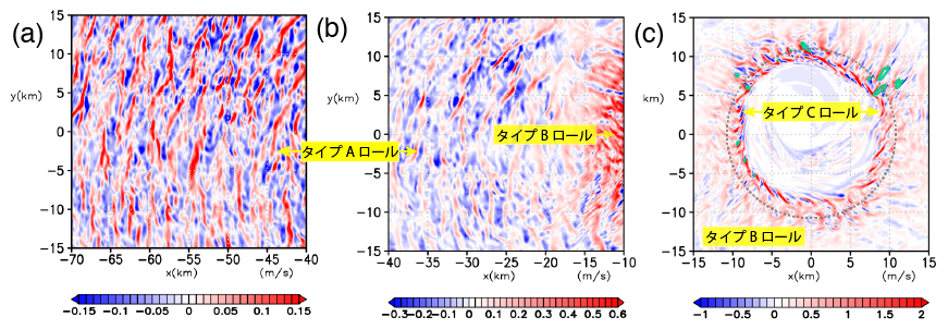
Figure 2. Vertical velocity and 3 types of rolle structures in horizontal planes at the height of 27 m from (a) the outiside to (c) inside, where red and blue colors are updrafts and downdrafts, respectively. The green contours in (c) indicate areas where surface wind speeds exceed 55 m/s.