Topics 2022.01.11
Introduction of study group on machine learning in the Department of Geophysics and an example of research
AI has now been widely introduced to many fields of science. Geophysics is not the exception. Many papers have been published day by day. In our department, a wide variety of researches related to AI is ongoing: phase picking on seismic waves, waveform-based event classification related to seismic and volcanic activities and prediction of ground motion based on underground seismic records in "Field A", observation/estimation of atmospheric/meteorological environment from satellite- and ground-based instruments (see Topics # 27) and estimation of instantaneous surface momentum fluxes in boundary layers in "Field B", and identification of solar radio burst based on machine learning in "Field C."
Under this situation, our Department organized an interdisciplinary study group on machine learning in 2020. The contents include text reading, the introduction of papers or research, seminars by many researchers, practice using python, and an application to real geophysical observation. More than 60 members including undergraduate students to professors have joined the group. Their motivations are also wide: some would like to use machine learning on their own research, to get a job related to data science, just to know what machine learning is. This situation may be a result of a recent trend in the world.
Here we introduce an example of machine learning-based research in our department: classification of local earthquakes and tremors in Sanriku‑oki, Japan, using seafloor seismic observation (S‑net) data (Takahashi et al. 2021).
Slow earthquakes characterized by a slower fault motion compared to regular earthquakes in the same magnitude have been widely detected in many subduction zones. Tremors are one kind of slow earthquakes and are located adjacent to seismogenic zones. Therefore detection of tremors is one of the key criteria for advancing our understanding of tectonic processes in subduction zones.
Tremors are often detected based on the similarity of the enveloped of observed waveforms. However, this method detects regular earthquakes as well, and visual inspection is essential in the final process. To reduce such manual cost, Nakano et al. (2019) proposed a supervised convolutional neural network (CNN) to classify local earthquakes, tremors, and noise using the spectrograms obtained by ocean seismometers in the Nankai subduction zone, southwest Japan. Following this study, Takahashi et al. (2021) optimized CNN to adjust the records in the Japan Trench, northeast Japan, and attempted to classify local earthquakes, tremors, and noise. In this region, it is important to discriminate local earthquakes and tremors due to the coexistence of regular and slow earthquakes.
We utilized spectrograms as input images in CNN (Fig. 1). Since spectrograms directly represent dominant frequencies of the observed waveforms and tremors are dominant in low frequency bands compared to local earthquakes, spectrograms are useful to capture the difference in dominant frequencies between local earthquakes and tremors.
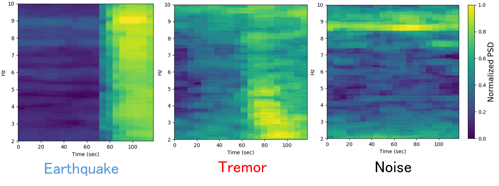
Fig. 1: Examples of spectrograms on earthquake, tremor, and noise.
Applying to the observed record at a single station located off Iwate, we successfully classified 100%、96%、98% of the earthquakes, tremors, and noise, respectively. The output probabilities for the true classifications decrease with increasing epicentral distance and/or decreasing event magnitude.
We also showed a successful application of our method to continuous waveform data including a tremor to explore the feasibility of the proposed method in classifying tremors and noise in continuous streaming data (Fig. 2). Future usage of multiple stations and construction of machine learning techniques will lead to continuous monitoring of tremor activities along the Japan Trench.
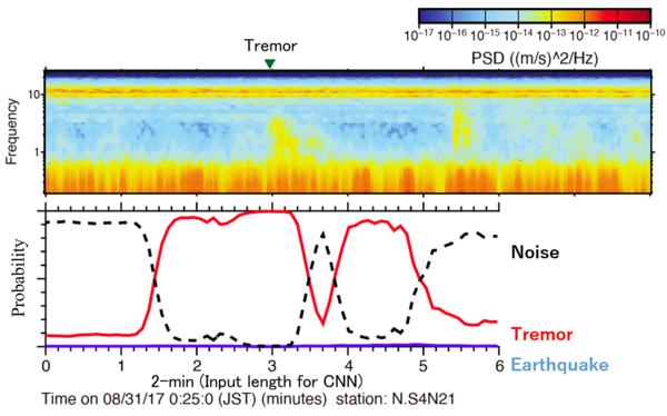
Fig. 2: Application to continuous records.
Acknowledgments: We used S-net data provided by the National Research Institute for Earth Science and Disaster Resilience.
Masayuki Kano (Solid Earth Physics Lab.), Shotaro Sakai (Planetary Atmosphere Physics Laboratory, Planetary Plasma and Atmospheric Research Center), Hidenobu Takahashi (Research Center for Prediction of Earthquakes and Volcanic Eruptions, graduated, Ph. D in 2020)